Showing posts with label trail running. Show all posts

Wednesday, 15 September 2021

Running the 50km Mont-Aux-Sources Challenge in the Drakensberg, South Africa


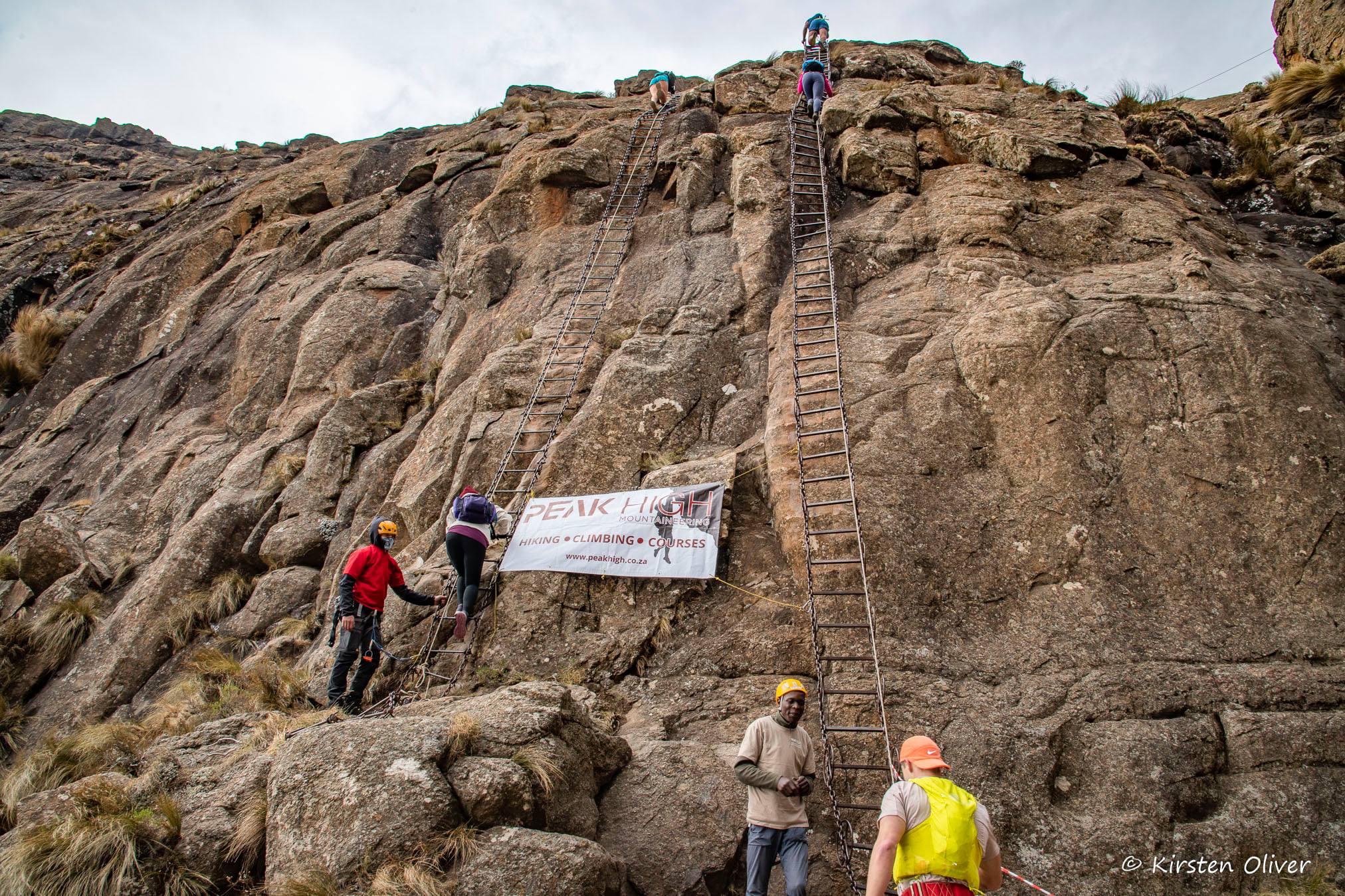
Exiting the chain ladders to the summit plateau

I gripped the first rung in the gyrating “ladder”. “Focus, think, concentrate” I said to myself. All I had to do was ascend this darn thing for 20 metres and I would be on the summit plateau at over 3000 metres. Yet so much could go wrong, especially with my cavalier finesse for not paying attention.

One ladder rung at a time. One hand, then a foot, then a hand, and so on. Three point climbing. Don’t be clever. Or fast.

My eyes peeped above the “within-grasp” horizon. The expert attendants unclipped me from the safety rope and I was ushered forward into big sky territory. This was the top. The hard part was done. The climbing was behind and from here it was all downhill. Kind of.

Drakensberg Amphithearte, South Africa

It had started six weeks earlier. The out-of-the blue email announced: “We’re happening. The Mont-Aux-Sources Challenge is on!". Covid lockdowns had ratcheted down a level and set forth a stampede of trail event confirmations. I paid my money and swore allegiance. I was in. This was my run.

The 50km Mont-Aux-Sources Challenge, hosted by the very competent WildSeries team, is promoted as SA’s queen of trail runs. Irrespective of being a queen it is quite ruthless in heading straight up the Drakensberg for about 25km’s to the “mount of sources (rivers that is)” at over 3000m and then more or less straight back down again. The total ascent as per my watch later was a little more than 2200m. Not too bad on paper, bad enough in delivery!

Six weeks of training meant two weeks for ramping up effort, two weeks for peaking (optimistic term for me) and two weeks of tapering. A miracle of schedule miniaturisation, unmatched in training journals, was my goal.

And six weeks later I apprehensively headed to the Drakensberg with at least one training run of 17km on the road, my longest. To help, I had fashioned a new pair of sandals with a hint of reinforcement under the balls of the feet to guard against sharp stones. I used these to run a few hill repeats at Klippies* and they felt quite good while being relatively light too.

Upon arrival mandatory covid testing ensured we were good to enter the Mahai campsite where I quickly pitched a tent and registered for the next mornings run.

Who sleeps well before a big race? Definitely not after 4am by which stage I was brewing coffee while eating muffins and dates. Time crawled until the race start especially as my group was scheduled for departure at 5:50am almost 2 hours away. It was good. 5:50am meant that I could get away with not wearing a headlight which meant a weight saving over the entire route.

Two minutes before my start a lapse of memory (increasingly frequent nowadays) saw me hastily unpack my trail bag to check that all items were included. Why the self-doubt? Nothing was missing and I loped into the start zone with a handful of talkative runners and 20 seconds spare.

The first 10 kays out of the valley to the top of the “little berg” were very reaffirming. I was cautious, slow and deliberate. Focussing on cadence and footstrike I tried to be light and nimble in the now. The pathway was good, the light sublime, the air unmoving and the scenery ageless. Not paying attention to others, I listened to my breathing, set minor goals by the tens or hundreds of metres as I sank into my zone.

I passed a few others and realised the first 10 kilometres where almost done as we approached Witsieshoek, a refreshment point almost halfway up this mountain of basalt. By now we were up about a 1000 metres and the altitude started to impinge on my well-being. Many years ago I had experienced a bout of altitude sickness** in the Drakensberg spending a night at 3000m vomiting and nauseous. This memory lived on.

One of my many failings over the years has been an inability to master nutrition on the long run. Sometimes I have managed quite well and at other times it’s been a disaster. On this occasion I had made a mental note to “eat” but even so conditions were railing against me. It was significantly cooler than anticipated and I had moved up the first section of the race more easily than expected. At Witsieshoek I refilled water, swallowed some gel and moved on.

And then, it came into view. Incredible! The next 10 kilometres and 700 or 800 metres of ascent soared above. Minuscule runners were hard to spot under the hundreds of metres of basalt cliffs. The spectre was astounding and terrifying. Me? Up there? The immense scale cemented the word ‘challenge’ in the Mont-Aux-Sources trail run. Damned if you don’t, damned if you do.

This is what we seek. The drama of nature. And us as insects on the canvas. Lyrical, poetic, tragic. I still had so far to go. I greeted the support crew at the base of the chain ladders. “Are your feet OK?” I was asked. “My feet are fine! It’s my legs that are not OK!” I retorted.

Working my way up and over the chain ladders to the summit brought a certain trepidation ... dressed as insouciance. Nausea was now my close companion. The distance across the lumpy tufted high plateau looked ominous. The cold wind howled hungrily and out-of-the-blue rain pelted my fragile legs. A gusty marshal tent beckoned far ahead. “Get there” I said.
Beforehand we had been told, “once atop the Berg wonder over to the edge of the escapement and look mesmerisingly at the Tugela Falls – the world’s highest – as they plunge from the top of Mont-Aux-Sources”. Such touristic niceties escaped me as I turned northwards following the direct route to the top of the Gully, our escape route from this playground of eagles. And vultures. And trolls.

The lone runner about 80 metres ahead of me suddenly stopped. Removing his pack in the fierce breeze he wrestled is leggings from the compartment and fitted the flailing fabric with erratic moves. I watched. He was doing the right thing and my cold limbs messaged me to do the same. Think, act, do. Yes, I could be a hero too! But damn it, it was hard, like trying to swot a fly with a dishcloth. I toiled agilely, subduing my lycra legging quarry in the wind and moved, better dressed, to the top of the Gully.

I had never been to this part of the Drakensberg and I had no idea what the Gully was. Surprising me was the stout roped cast down its narrow and steep confines. I clutched the rope and moved down the loose scree. This was cool as long was no one above you dislodged rocks to cascade into your head. Perhaps it wasn’t as steep as my fears suggested. 

Exiting the Gully the helpful race crew greeted me while secretly checking that I wasn’t certifiably a danger to myself. They permitted me to continue.

The long, long descent started from this point. I had made a commitment to eat properly. But everything had gone wrong, again. I felt drawn and quartered, I prayed for more oxygen, I knew cramps were a heartbeat away. Stopping to urinate, which is a good sign, I saw my urine was deep brown, which is not a good sign. I immediately started drinking. Much more. My nausea waned.

Struggling, I watched as a few runners passed me with little effort. I needed something and at a pop-up refreshment station I ate potatoes and bananas with some water and a big restock of water bottles. Moving forward I started to feel better and by the time I turned back onto the pretty mountain path, which would guide me downhill to the Mahai starting point, I moved with increased resolve and marginal purpose. Interestingly my 5km splits going up were the same as those coming down.

The Drakensberg is spectacular. Moving across its geography is alluring and enticing. The seduction is complete when you run out of air and legs, with only the vista as your friend. Beautiful as it is, you always have further to go, on less.

Thanks to WildSeries for hosting this beautiful event. Again. 

I completed my run in Vegan Ultras a hybrid sandal used by a handful of ultra runners. It has a 12mm three-compound sole including a softer midsole, a grippy non-slip footbed and a treaded (but not overly) outer sole. The lacing is from the Vegan X. It works.


 * Klipriviersberg Nature Reserve

** Although rare, altitude sickness can occur at levels as low as 3000m because the illness is more a result of the rate of change in altitude than the actual specific altitude level.


Tuesday, 13 September 2016

A Lite Ultra in Ireland - Kerry Way Ultralite

Bucolic Ireland beckoned. Green, green and more green. Fertile and fecund. And rain and rain and yet more rain between the showers. "A soft trail" they said, "no mud".


Taking the Emirates route via Dubai I flew the long way to Dublin. Perhaps 18 hours. I forget. But the good people were there to meet and I was hustled into the car for the next 5 hour leg to Killarney, near the western seaboard, and home of the start and finish of the Kerry Way Ultra and the finish of the Ultralite runs. (The 120 mile Kerry Way Ultra is a circular route while the 55km Ultralite is a point-to-point route starting in Sneem and finishing with the bigger run in Killarney).


Why I had agreed to this run escapes me. There was no good reason other than it looked like a nice place to run with a profusion of seductive and captivating pictures littering the internet. I am a real sucker for pretty places. So Killarney it was and on arrival it was explained that this town, in the Kerry district, is the heart of holiday country in Ireland, luring visitors from all over and especially from America.


Killarney is a small town with a vibrant tourist buzz contrasting with the relaxed demeanour of the locals. It was also surprisingly busy with vehicular traffic, alarmingly interpolated with anachronistic horse carts. The tolerance and respect for the equine tradition was a real eye-opener and increased my respect for the locals exponentially even though I do not have a distinctive affinity for horses. I knew I was amongst a people that cared.

The Kerry Way Ultra is a mad thing. I have said this before and I stick to it. It's a 120 miles of madness, and a solid 60 miles of madness beyond my own affliction. However in 2016 they introduced the Ultralite which at a meagre 55 kilometers was an instant "yes" for me.
The day before my run I was at the briefing and the start of the big 120 mile event which left Killarney at 6am on a Friday morning at an unremarkable location on a main road exiting the town. The group of about 50 ultra-ultra runners left in good spirit and weather, with the first rays of sunshine awaiting 20 minutes ahead. I walked back to my hotel and started eating peanut butter sandwiches. I had a day to pack in the carbs and fats that I thought might help me on my "short" run and 6am was a fine time to start the grazing.

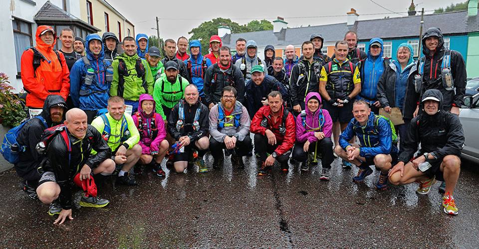
Beautiful people at the start of the 120 mile Kerry Way Ultra 

Before arriving in Killarney I had liaised with a few locals in an attempt to get an idea of the terrain and the footwear that it would tolerate. In all honesty, having now run the route I can safely say that the locals were either taking the "piss out of me" or they are of a significantly sturdier strain of homo erectus. (Could it be the Vikings that settled in Ireland over a 1000 years ago?). Put simply the Kerry Way Ultralite was, for me, tough going and damaging to my feet. It was far from what I had expected . But it is still one of the finer runs I have done.

55km Kerry Way Ultralite runners at their start - with rain

Awakening on Saturday morning, a few hours before the start in Sneem, I peered through the hotel window into the early morning darkness. Then I heard the rain. Damn, it was raining. And when I looked downwards at the wet gardens and contemplated how soundly I had slept, it dawned on me that it had probably been raining all night. In an instant I knew my preferred sandals would not be good for the run. I simply could not afford the risk especially in unknown territory. The Newtons would have to do it and that was that.


The night of deep sleep, before the start, was a signal of the issues we faced. More specifically it was the rain during the night which continued well into the run. Leaving the hamlet of Sneem which is where the 55km run starts we pranced down a stony twin track which was actually two small streams running side by side abutted with treacherously muddy mud. Running in the streamlet was manageable but occasionally I ventured sideways to step on what looked like a drier piece of turf only to sink ankle deep in mud with the accompaniment of audible profanity. Thloooschp ... I pulled my foot upwards, escaping the scatalogical mud but.... but leaving my loosely laced shoe haplessly trapped in the boorish clay coelenterate. This will end soon I thought optimistically at 500 meters into the ultra. And so it did at around 35 kilometers and then only for a while. As they say: death is the only cure for stupidity.

How deep is it?

Mud of the order that Ireland presented on the day I ran the Kerry Way Ultralite was of diabolical proportions. The were vast landscapes of mud. Entire hills of mud, often mixed with eons of cow and sheep faeces. The redolent odour from my shoes, since thoroughly washed twice, confirms this assessment. And there were styles. At first playful little obstacles mildly challenging in the wet but after 20 or 30 of them I had visions of slipping and (in South African colloquialism), "blikseming off and moering" my head into the mud ... or a rock. At times there were wooden planks, coated with wire, placed over the perpetually muddy sections to offer light relief. At times there were also insidious and perfidious deep bogs. These were life-sapping death pits from which the paleontologists regularly extract cured remains of early Gaelic people. I know of runners that sank chest deep into some of these soupy carcass-craving bogs.


The Kerry Way runs follow the Kerry Way walking route which is a mix of mountain path, track and some roads through local villages. This kind of mixed terrain produces very interesting and engaging running especially for the likes of me who is known to miss key signposts. I knew the start of my run was in a small village called Sneem and I knew we would also run through other small locations with quaint names such as Templenoe and Kenmare. Knowledge is a powerful tool and in preparation I had looked at the route profile at least once. There was only one thing I remembered - the climbs start at about 35 kilometers. Thus in perfect synchronicity at 35 kilometers coming over a small rise into Kenmare my right hamstring capriciously cramped reducing my jog to an instant hobble. I passed two men who immediately pulled a fresh unopened bottle of water from a bag and insisted that I drink as much as I needed. What generous people? Gladly I accepted realising that I had not been drinking enough. My legs eased and I started moving. At the checkpoint I removed my shoes to pour out a collection of Irish rocks, stones, sticks, gravel and the odd boulder that I had gathered and carried since the start at Sneem. I saw the chafed, raw and bleeding holes in my feet and the helpers were very quick to offer plasters and other remedial wrapping. I declined. The damage was done. I really didn't care. I was happy.

One of a few mud-and-gravel-abraded "holes" in my feet.
My shoes were hopelessly too loose and I didn't bother to
retie the laces

The rain persisted and running from Kenmare to Killarney the route takes a long and steady climb over a series of hills taking one into the heart of Kerry countryside. What a splendour. The cloud colours, fast and black, grey and white, descending and rising. The wind, cold and vocal. The green, orange, purple heaving terrain. The abundant rivers, black water and fervent froth breaking banks, flowing forcefully. I was deliriously lost in the remoteness .... deliriously also missing the vital turn-off and gleefully running an unnecessary mile to a small road where cyclists pointed out that I was not where I should be. "Go back" they said "and look for a little path that goes off to the left". Fine people the Irish.


There were so many really good encounters on the run. The people were really exceptional. Everybody. The last 5 kilometers to the finish in Killarney is through the Killarney National Park which includes Muckross Lake and Lough Leane, an even bigger lake. What better time to run through this expanse than on a Saturday afternoon with all the other visitors - a revivifying treat capping a wonderful day.

And then the finish, in true spartan glory ... on the sidewalk at a rather unremarkable spot, but at least in Killarney.


Pictures include those provided by the organiser and are of both the 120 mile and 55km  overlapping event.


Some details: Entry to the Kerry Way is limited. I think about 50 entered both the 120 mile Ultra and the 55km Ultralite. More than half of the 120 mile Ultra starters did not finish. While many do not normally finish the rain and thick mist were additional issues in 2016. I think all starters of the 55km run finished but about 10 failed to show up at the start - did the weather put them off?

Saturday, 7 September 2013

PUFfeR: 80km Ultra Trail Run in Cape Town

Puffer is an acronym of sorts for Peninsula Ultra Fun Run - PUFfeR. This is my experience.

We were sitting on buses and trundling in the darkness towards Cape Point, the rocky promenade that extends south from Cape Town ending in a sharp and precipitous knife-edge that drops into the ocean.. This was where, they say, the Atlantic and Indian Oceans meet. I wasn't sure if it was true, but it makes for a good story and  it certainly made me feel like a pioneer as we headed south away from Cape Town.


It was pitch dark and the bus was obviously travelling very slowly. The trip took forever and they kept the lights on the bus so that all the runners could see each other as they babbled and bantered about previous running adventures. I sat quietly on the seat and looked around. Everyone seemed to have lights mounted on their foreheads. I didn't have any surplus kit and I wondered if it would be the first decision I'd regret.

Eventually the bus slowed down and made a u-turn coming to a standstill facing the direction from where we had come. Silence descended as everyone clambered off, and like lost spacemen, people wondered off into the foliage to relieve themselves. Yet more runners were gathering around the public toilets, eerily lit in the weak florescent glow of an old light bulb.

How it happened is unclear, but something prompted the dispersed group of about 120 runners to move northwards in the large parking area to a point where there were two warmly clad men, one of whom produced a gun. I couldn't hear what they were saying and with the first attempt at firing the starters gun .... nothing happened. The group burst into agitated chatter and then the mans arm went up again, the gun fired, and we started to move, running along the tar stretch back to the entrance of the Cape Point Nature Reserve from where we had come.


Quickly the runners spread out and I saw that my lack of headlight was no hindrance. The road was in very good nick and the light from others made an additional headlight redundant. I also hate unnecessary baggage. And so I jogged along in the darkness wondering what pace I should be aiming for. Academic stuff really. I couldn't see my watch. I had no idea of distance. The pace was whatever it was. But it didn't take long for the group to spread and I was soon running on my own in perfect blackness with a faint glow appearing to our left ahead of the rising sun.

After leaving the Nature Reserve the PUFfeR stays on tar for about another 20 kays which means that many serious trail runners are somewhat disparaging about this event. But I knew what was coming later. I knew the terrain over Constantiaberg and Table Mountain because I had run a lot on these mountains many years earlier when I lived in Cape Town. And so the tar didn't bother me. I was satisfied that we were really doing a mountain run. The tar portion was a warm up and quite a hard one too, climbing for a few kilometers over Redhill near Simonstown. By this stage I was starting to get a little worried because so many runners were moving faster than I was and I had no idea how to calculate a pacing plan. Being so far behind where I thought I should be left me feeling despondent.

At about 25 kays the route suddenly veered off to the left onto a single track pathway on soft sand through the famous Cape fynbos (indigenous Cape flora). This was it! Here it was! I was very excited. The thick smell of the fynbos hanging in the damp air, and the crunchy sand underfoot was so reminiscent of what I had loved years earlier. It was like entering an earthbound tangible "heaven". I was so comfortable. My soul, in out-of-body levitation, I felt light and strong. While overhead the clouds hung low and the sunlight failed to break through. The temperature was low enough to wear a long-sleeved top but I stuck to a t-shirt.


After some more path-finding through the fynbos we eventually headed around the back of Fish Hoek on some large tar roads and some busy Saturday junctions. This was another reason that some trail junkies turned their noses up at the PUFfeR but for me it just added to the texture and ambience of the run. Exiting Fish Hoek I found my mate Trevor, standing starkly upright alongside the road. I looked forward to him joining me for the remainder of the run as a second. Who knows what the distance was, but I think it was close to 40 kays which meant about 40 kays to go. So we still had quite a lot ahead of us, in fact, quite a lot of hard stuff.

Soon we reached a large refreshment station and I tanked up on Rehydrate, a big chelsea bun and some water from the welcoming helpers. Leaving this water point we slowly worked our way through the Silvermine Reserve and I managed to unleash such a constant torrent of verbosity that I missed most of the surrounds. Trevor generally is a very taciturn fellow, but on this day he was beyond loquacious as was I. We chatted incessantly like a pair of old ladies (is that politically incorrect?).

I do recall some very steep rocky inclines and some sandy sections and I recall that we lost our way at one point. Eventually seeing a few runners in the thick fynbos away to our left, we were able to head in the direction required. My earlier euphoria at entering the fynbos was not enduring. The Cape had had so much rain that most of the local vegetation now stood at anywhere from 6 foot to 10 foot tall, which meant that it was often impossible to get one's bearings. You just couldn't see beyond the path!


After leaving the Cape Point Nature Reserve a lot of runners had  passed me. I hadn't panicked but I had entered a mild state of dejection and fear of being left behind especially on some of the long uphills. But now in Silvermine, about 50 kays from the start, things were starting to change. I wasn't getting "dropped", and on some of the ascents I was actually gaining ground. This dear reader, is very motivating.

It wasn't long, after ascending quite a way up Canstantiaberg that the route made a steep and long descent to connect with a contour path which would eventually lead to another mountain (Vlakkenberg) and yet further on, to Constantia Neck at the back of Table Mountain. There was still so much to do! But I was getting inspired. I knew that I could get "downhill" fairly quickly and by this I mean down mountain paths. And the steeper, rockier, the better. With the tar behind us and the terrain becoming a little more technical I had a better chance! So I decided to start moving with a bit more conviction and managed to catch up with a few runners up ahead. I didn't want to push too much but felt good knowing that I could still cover ground fairly quickly, if needed.


Constantiaberg with the cave on the right known as Elephants Eye
On our way to the Vlakkenberg Trevor starting dropping behind and I knew I couldn't wait for him. I felt certain that something had happened to cause his loss of pace. It turned out later he had been sick since the previous day but did not want to let me down on "race" day. He should have been in bed! So, a fine guy all round!

Looking back up Vlakkenberg - Dutch for flat mountain
After Vlakkenberg came the Constantia Neck refreshment station. Again I took in more Rehydrate and chelsea buns. I dilly-dallied for a while, chatting and messing around, giving up about 15 minutes, and then headed up the very steep path that leads to the back of Table Mountain, otherwise known as the Back Table.

The pictures are from 2 years that I ran the PUFfeR. The second time in sandals. Here, approaching the Constantia Neck waterpoint.
This was it. This was my territory. I kept talking to myself. I stopped worrying about cramps and any other inconvenience. I wanted to move. Where were the other runners? I searched ahead but could only make out one shape in front. Dammit! Keep moving I said. Just MOVE. I wanted that person. I wanted to catch up? Move, move, move! We were about 20 kays from the finish and the best bits lay ahead. We had moved higher and the fynbos was shorter. Nothing more than 2 feet. It was all short grassy scrub and a lot of course, crystalline sandstone. I loved it.


At every point possible, I would break into a quick jog. And then more clambering. Rocks, gullies, ditches, water, steps.

Run, sidestep, lunge, clamber, run. Move, move, move. Great! And the human shape ahead drew closer and as he came into focus I saw it was Paul who had been running with Trevor and I on Constantiaberg. Darn! I should never have spent so much time at the Neck. I greeted him and moved on. The top of Table Mountain was still about 250 meters higher and possibly about 1 or 2 kilometers ahead. Now I could see many other runners. Little groups of 3 or 4. Go go go.


On the way to Maclears Beacon at the summit of Table Mountain I managed to pass 26 runners. I counted. I loved it. At the summit there was another checkpoint and refreshment station. I hardly stopped. I gulped down a bit of water and kept moving. The top of Table Mountain is indeed a beautiful place. Very flat and quite eerie in it's own way. It's big too. Getting from one side to the other can take a long time. Someone once told me it's 4 kilometers wide. Who cares. I was moving and feeling good despite the occasional cramping twinges in my legs.


Looking down Platteklip Gorge from the top of Table Mountain
The day was still sublime, with low clouds, no wind and a soft light casting a surreal glow. It felt as though I was living in a movie scene. But the ethereal peace and abeyance of pain is over when you get to the start of Platteklip Gorge, the perilous knee pounding, rock strewn route down the front of Table Mountain. Platteklip Gorge is ridiculous. They call them steps but the rocks, re-positioned on the handmade pathway, are a jagged, contorted mess of careless geography.


Platteklip Gorge descends diagonally down the front of Table Mountain starting about 2 thirds of the distance from the summit on the far left to the Cable Station on the far right
In 2015 during my second running of this event I happened to be around when a runner had had an accident and needed to be airlifted out of Platteklip Gorge. We had to wait for the evacuation.

A runner rescue after an accident in Platteklip Gorge 2015
The view to the finish near the harbour from Table Mountain
To get down Platteklip Gorge you have to employ, in random succession, a series of lunges, plunges, leaps, bounces and hurdles. At every point you feel you are a hairs breadth from diving head first into a pile of capriciously strewn boulders. And some do. But I loved it. This was downhill. I rushed ahead with relentless abandon.

Coming after the Platteklip descent are a few busy roads and a dismal pathway down the side of Signal Hill which again ensured a route finding mishap. I just couldn't run on ahead because I didn't know the way and when others caught up with me, they too either didn't know the way or were so stricken with cramps that we had keep stopping for a thigh or calf massage. But I got to the finish, at the oceans edge next to the Cape Town harbour, quite delirious and fortunately, quite bouncy.

My parents had visited to support on both times I ran this event
The PUFfeR is a splendid run. Quite exceptional in fact. As youngsters Trevor and I had made a "sport" of running up and down Table Mountain. We did it for fun when none had even thought of running on a mountain and trail running, as a concept, had yet to be invented. (At the time there were indeed a few runners in Scotland and Wales who had started "fell" running.)

So, getting back to Table Mountain after years of absence was superb and finishing second in the masters group simply felt good. But then ... it's not a race.

You can make contact with the organisers (Fish Hoek Athletic Club) here: www.facebook.com/PufferTrailRun/
or  www.fishhoekac.com/services/the-puffer